
Old postcards of Prague St Adalbert´s Quarter
335 - The Šítkovská rafting-yard with the southern part of the Vojtěšská čtvrť (St Adalbert’s Quarter) before the clearance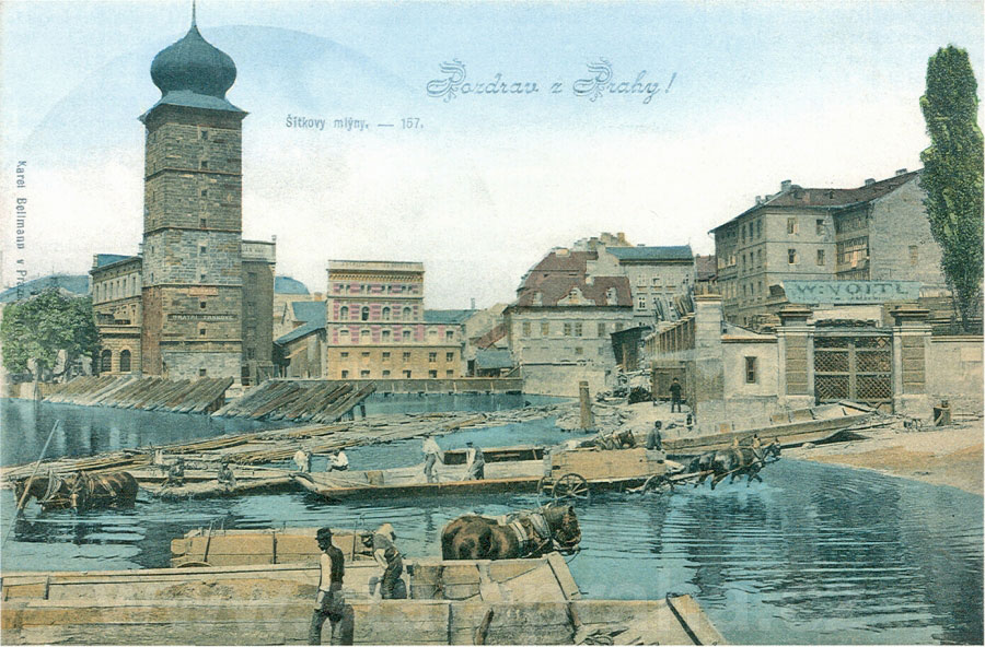
In the course of the clearance the whole group of buildings on the right was demolished and a new route for the elevated and extended embankment started running from the third window beam of the mill building No. 249 (see picture 348). This embankment saw the gradual construction of residential blocks designed by the most renowned architects of the period. The mill buildings on the left of the picture survived the clearance and were not demolished until 1927, when their site was occupied by the Mánes Association of Artists. This area was usually very hectic; in summer sand was exploited from the river bed and in winter ice-breaking was pursued here - ice floes were cut for the Prague grocery businesses. Both of these activities were traditionally carried out by the inhabitants of the nearby area of Podskalí. This idyllic picture of the end of the 19th century depicts the Šítkovská Waterworks Tower, which for centuries supplied the fountains and wells of this part of the city with water. Beyond the tower you can see the Vávra Mill, No. 251, on the right another mill building with an angular front, No. 249, dating from 1880 and hiding from view an older building with a ridge roof. The house with the Baroque facade in its neighbourhood bears the number 248. In the foreground you can see the Bubeníček timber yard and behind it, on the right, two houses, Nos. 265 and 1572 (see picture 348), in Náplavní Street. COLOURED PHOTOTYPE. K. BELLMANN, 1900
|
336 - A view from an iron access way linking Žofín Island with the small Tylovo Square behind the National Theatre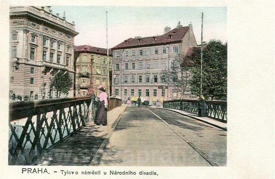
On the left you can see a part of the rear wing of the National Theatre, originally a narrow three-storey house. It was included, along with the building of the Temporary Theatre, after due modification and unification of the facade between 1882 and 1883 by the architect Schulz, into the original building of the National Theatre, designed by Zítek after its reconstruction following the fire of 1881. On the corner of the Divadelní (Theatre) and Ostrovní (Island) Streets there is No. 225 (today the administrative building of the National Theatre of 1983 occupies its site), in the middle one can see a three-storey building, No. 1386, on the right behind the trees a lower house, No. 1648. The last house mentioned adjoins another three-storey house (out of the picture) at the corner of Na Struze Street (see picture 342). These houses were demolished in 1905 and replaced by a massive street front of Neo-Gothic-Art Nouveau houses. KOLOROVANÝ SVĚTLOTISK. F. J. JEDLIČKA, AROUND 1900
|
337 - A swimming-pool on Žofín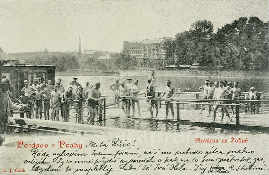
In the background there is a part of the Střelecký (Fusilier) Island and buildings on the Smíchov embankment. On the Barvířský (Dyer’s) Island, which was the original name of Žofín, bathing cabins located on rafts appeared as early as in the early 19th century. The river baths, as the swimming-pool was referred to at that time, were established as late as 1884 and in the beginning housed 50 cabins. Legend has it that the water in these spots was the cleanest, apparently due to the presence of a stronger current. In the picture you can see men only, as public morality at that time required a separation of men and women when bathing. However, that there had been exceptions at that time is substantiated by pictures and even postcards showing men and women bathing together in summer resorts such as Lake Balaton, Luhačovice spa, the women wearing all-concealing bathing suits. PHOTOTYPE. L. J. ČECH, 1899 |
338 - The southern part of the community centre on Žofín with the garden restaurant of F. Krátký
Its park and restaurant were traditionally a meeting point for the middle and upper classes, unlike the pub on the nearby Střelecký (Fusilier) Island, the atmosphere of which was more popular. Žofín was also frequented by governesses with the children in their charge, by families going for a Sunday walk, and marriageable girls accompanied by chaperones who were looking for an opportunity to meet someone. The sailor suits of the children of the above-mentioned social classes, in the foreground of the picture, were uniform for all between the ages of three and twelve revealing the lack of imagination of the designers. Of the number of events that took place on Žofín Island one should at least be mentioned: in 1841, i.e. four years before Prague saw the first train, two English engineers introduced a small steam engine here with a few carriages which covered a 160-metre route. COLOURED PHOTOTYPE. PROBABLY F. KRÁTKÝ, AROUND 1906 |
339 - St Adalbert’s Church
St Adalbert’s Church with a bell-tower and the old building of the basic school at St Adalbert, No. 202, viewed from Pštrossova Street. The Church, the core of which is Gothic, was constructed on the site of its Romanesque predecessor. It used to occupy the area inhabited by tanners and tawers who also pursued their activities here before the construction of the New Town. The Church was modified in the 17th and 18th centuries, in the 1870s it was made Gothic again. On the right, in front of the bell-tower of 1700, you can see a house of the oldest housing area, the so-called parish house, No. 201 - it was here that the composer B. Foerster spent his childhood. In the background, beside the Church above the parochial house, No. 214, you can also see a part of the roof of a house of the newly established Šítkova Street, new No. 240 (see picture 340). COLOURED PHOTOTYPE. PROBABLY F. J. JEDLIČKA, AROUND 1904 |
340 - A view from the extended Vojtěšská Street after the clearance to the north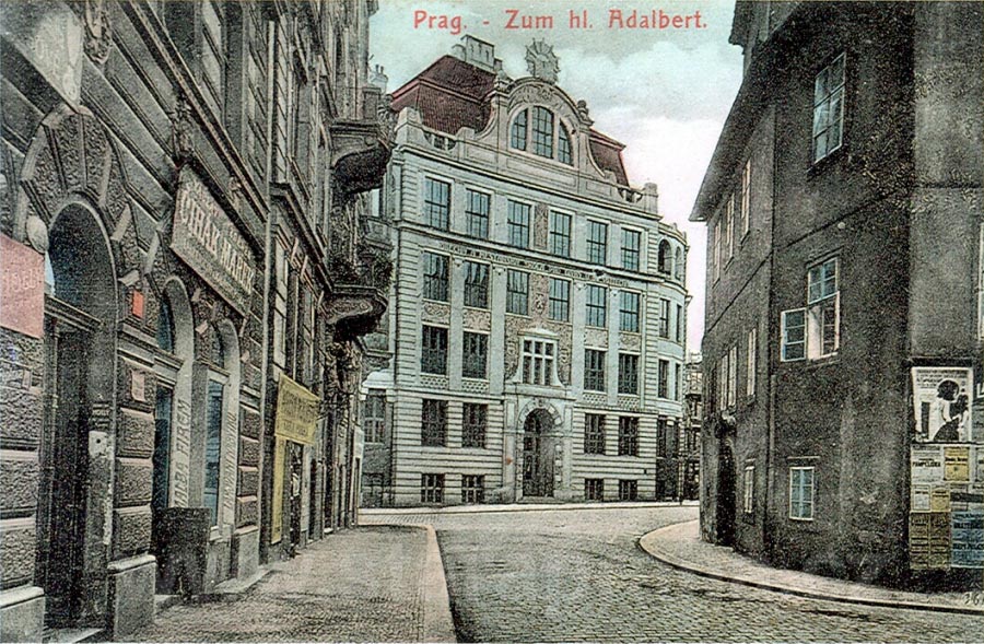
You are looking at the front of the Art Nouveau new building of the school for girls at St Adalbert, the new No. 216, facing the little square in front of the Church. The building was constructed on the site of the demolished buildings nos. 216 and 218 and a part of the former Šerlinská Lane, between 1904 and 1906. On the right in the street there is the parochial house of St Adalbert, which remained intact along with the Church. On the left you can see one of the first buildings of the new quarter, new No. 241, of 1895. The house behind it, on the corner of the new Šítkova Street (see pictures 339) came into being in 1903 approximately on the site of the former building, No. 213. COLOURED PHOTOTYPE. K. ZUNA, AROUND 1907
|
341 - Vojtěšská Street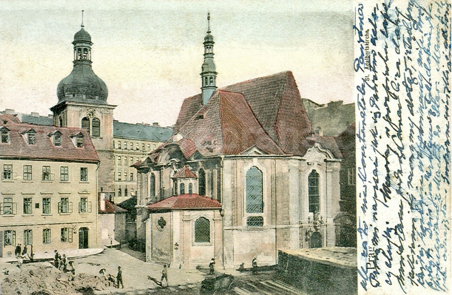
With the Church and the Baroque Chapel of the Holy Cross - a view from the Lodecké mills shortly before their demolition. In the foreground you can see workers clearing up the rubble from the demolished buildings Nos. 216, 215 and 213. This resulted in the extention of Vojtěšská Street, which was narrow until then, as well as in the creation of a small square before the Church, the northern part of which is closed off by a new school building (see picture 340). On the right the construction of a building at the corner of the newly established Šítkova Street has been launched, No. 217, to the left of the bell-tower, and it shall not be demolished until 1933 when its site shall be occupied by a Functionalist residential building. In the background you can see a number of buildings in the eastern part of Pštrossova Street. COLOURED PHOTOTYPE. F. J. JEDLIČKA, 1903 |
342 - The New Baths viewed from the rear wing of the National Theatre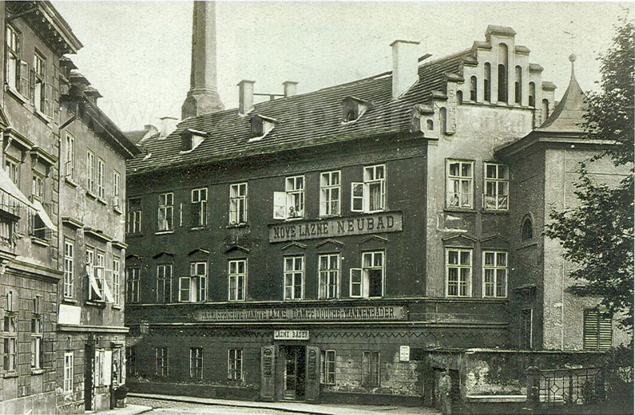
This building was the northernmost extremity of the clearance area between Na Struze Street, Tylovo Square and the river Vltava. It was a three-storey, Neo-Classical building with Romantic elements, constructed in the first half of the 19th century. Its rear (south-west) wall emerged directly from the surface of the Vltava opposite Žofín. In this area and its vicinity (where the present Café Slavia is located) there were baths as early as in the Middle Ages. They were still for both men and women. It was not until later that the social conventions required their partition into separate male and female parts. On the very left you can see building No. 1648. Beyond it, at the corner of Na Struze Street, there is another three-storey building, No. 227. After the demolition of the New Baths in 1903 the route of the new Riegrovo embankment ran through this area (with a shift of 30 degrees to the right - see picture 351.) PHOTOGRAPHIC POSTCARD. PICTURE AROUND 1900. Z. REACH, 1920s |
343 - A view along Na Struze Street from the New Baths, located to the right (outside the picture)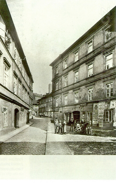
A four-storey residential block on the right, No. 230, adjoining the baths, bore a Neo-Classical facade at the time of the clearance, though it is undoubtedly of an older origin. Its side wings created a square courtyard, which probably housed workshops of a few artisans as is indicated by the signs on the building. Along with posters bearing advertisements of the period, the signs make the monotonous facade more varied. A tincture against insects is advertised here (100 ducats for a bug!), as well as Grün mineral water and the lemonade sweets of A. Maršner. Nevertheless, you can also find an invitation to a meeting of an institution, or to a concert. In front of the house you can see one of the most typical trades of the period, knife grinding, in action. Another building, with a chimney, bears No. 231 and is located at the corner of Vojtěšská Street. The building which stands out in the middle, in the background, is already a part of Pštrossova Street. On the left you can see a somewhat more refined house, No. 229, originating from the old complex of buildings. Beyond this you can see two new buildings, nos. 1739 and 1740, which shall create the core for the construction of a new street after the 1903 demolition of majority of the houses in the neighbourhood. PHOTOGRAPHIC POSTCARD. PICTURE AROUND 1900. Z. REACH, 1920s |
344 - The Šítkovské Mills viewed from the north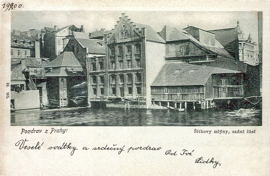
The Mills acquired their name after their 15th century owner J. Šitka. Mills on the banks of the Vltava started to be established as early as in the 10th and 11th centuries, using the power of the 12-metre fall in the level of the Vltava between Vyšehrad and Podbaba. In the centre of the picturesque group of buildings, differing in age and size, you can see No. 249, which was reconstructed and furbished with a relief shield in 1880. The buildings to its left and along the river bank were demolished as a part of the 1903 clearance. Building No. 249 remained intact until 1927 even after further modifications (see picture 349) along with the whole configuration on the right. In the background on the right you can see building, new No. 1772, from 1893 (with loggias in the Jindřichův Hradec Renaissance style) located on the Riegrovo (later Jiráskovo) Square until the present day. PHOTOTYPE. K. BELLMANN, 1899 |
345 - This snapshot is similar to that in picture No. 344, but was taken, however, from the newly constructed embankment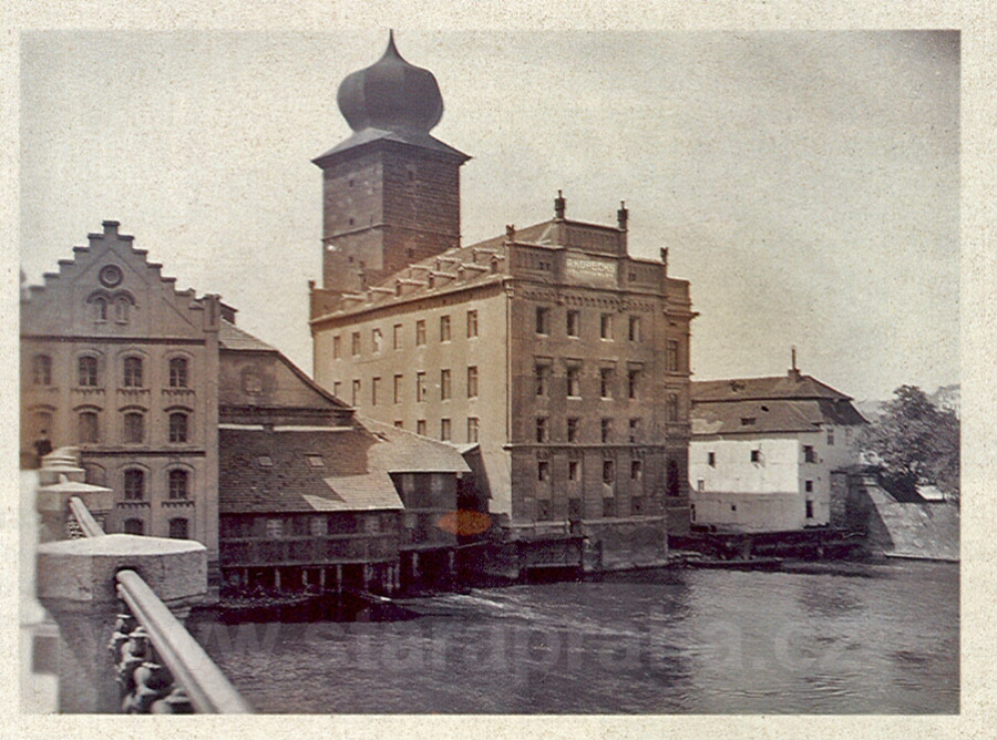
We are looking at the Šítkovské Mills, which did not interfere with the construction of the new embankment and therefore remained intact. Nevertheless, their demolition in the future was contemplated and was carried out in 1927 after which the new building of the Mánes Association of Artists was constructed on the site. Its front, however, was linked to the line of railings, running as far as the second row of windows of the old building No. 249, as seen in the picture. The building in the middle, No. 251, was a cylinder mill. The excellent work of the constructors of these mills can be substantiated by the fact that during the demolition works, the fixed foundations required a great deal of effort to be broken up, and it was also necessary to extract a few hundred piles which were deeply embedded in the river bed. PHOTOGRAPHIC POSTCARD. PICTURE 1903. Z. REACH, 1920s |
346 - A view through Myslíkova Street towards the Waterworks Tower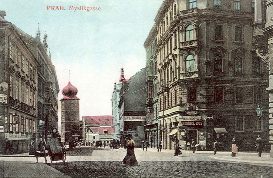
Following the clearance of St Adalbert’s Quarter this street, which had not previously been viable in terms of traffic, became one of the most frequented thoroughfares between the newly constructed embankment and the city centre. Tram tracks were also installed in this street. On the right, at the corner of Pštrossova Street, you can see a Neo-Baroque residential block, new No. 207. Another building beyond it, new No. 1922, was constructed on the same lot. Both buildings, constructed in 1895, were designed by F. Niklas. Behind the long building No. 208, which was from the original complex of buildings belonging to St Adalbert’s Quarter, jutting into the street you can see two large new buildings with little corner towers, completing the second southern block of the new complex of buildings between Riegrovo Square and Vojtěšská Street (see picture 348). In the background you can see the Waterworks Tower, with a typical onion-shaped Baroque cupola, and a side part of the mill, No. 249 (see picture 349), on the site of the present Mánes Building. COLOURED PHOTOTYPE. H. Z. ZUNA, AROUND 1905 |
347 - A panoramic view of St Adalbert’s Quarter via Žofín Island
St Adalbert’s Quarter is depicted in the period following the demolition of the old complex of buildings which saw the construction of new residential blocks on the newly built embankment. In the front line, immediately behind the trees on the left, you can still see uncleared buildings Nos. 1648, 227 and 229, as well as the northern construction block of the new complex of buildings, demarcated by the following streets: Na Struze, Vojtěšská, the new Šítkova (leading perpendicularly to the embankment from the Church of St Adalbert) and finally the southern block (to the right of the community centre on Žofín), demarcated by the streets Šítkova, Vojtěšská and Myslíkova. In the northern block you can see the rough construction of the first three buildings before completion. In the southern block a building (new No. 240) has been constructed opposite the parochial house. The two newly constructed blocks are clearly visible in pictures 349 and 351. On the little square in front of the Church there is still free space - a school building was constructed here two years later. In the middle of the background the town council tower overlooks the New Town roofs. PHOTOTYPE. AROUND 1904 |
348 - The southern part of St Adalbert’s Quarter with the Šítovské Mills and the new embankment following the clearance (see picture 335)
The embankment wall, linking the section of the Palacký Bridge which had been built earlier, extended the embankment on this site by about 30 metres, elevated the terrain at the entrance to Myslíkova Street and all the embankment streets could finally be interconnected. The ground floor and the second storey of the still existing mill buildings sank to ground level. The construction of new blocks on Riegrovo Embankment is entirely completed from this side. The eastern part of the front of the mill building No. 249 (in the middle), which interfered with the new thoroughfare, had to be removed. The new building with small corner towers on the right came into being on the site of the former Nos. 246, 247, and 248. On the very right you can still see No. 1572, one of the old complex of buildings which shall be demolished in 1906. COLOURED PHOTOTYPE. F. J. JEDLIČKA, 1905 |
349 - The Riegrovo Embankment from Myslíkova Street to the National Theatre
The decorative facades of the tall buildings, fashionably designed in a combination of Art Nouveau and elements of historicism, became an imposing backdrop enhancing the unpaved New Town Vltava bank. On the left you can see one of the buildings of the Šitkovské Mills, No. 249, the side front of which was modified with respect to the elevation of the ground level and beautification of the street. The building will be non-existent by 1927 when it will be replaced by the early Constructivist Mánes Building which was designed by O. Novotný. In the picture you can see two blocks with the new Šítkovská Street between them. Let us mention at least the third building from the right - it belonged to the singers’ association Hlahol. The construction of the building, which was designed by F. Schlafer and J. Fanta, was supervised and completed in 1905 by Č. Gregor, a builder who acquired fame reconstructing the Franz Josef I Railway Station (see the text of picture 486). The Hlahol choir was established in 1861. Its importance for Czech musical life has been significant. COLOURED PHOTOTYPE. H. Z. ZUNA, AROUND 1908
|
350 - The Žofín Baths
On the island of the same name, as viewed from the newly constructed embankment. Barvířský Ostrov (Dyer’s Island), later referred to as Žofín, saw wooden baths as early as around 1800, and these were reconstructed in the following years in various ways. The Neo-Classical complex of buildings seen in the picture was constructed for the Baths. Originally this arm of the river Vltava used to be twice as wide at this place (before the modification of the embankment). The Loďkové Mills, Nos. 1289-1291, existed until their demolition in 1903 on the original wider river bed, perpendicularly to the centre of the row of baths’ buildings on the Island. In the background you can see the rear part of the National Theatre. On the right a building on the corner of Na Struze Street, No. 224, is just being completed (see picture 351). COLOURED PHOTOTYPE. O. ZŮNA, 1906 |
351 - The newly completed street front of the Riegrovo Embankment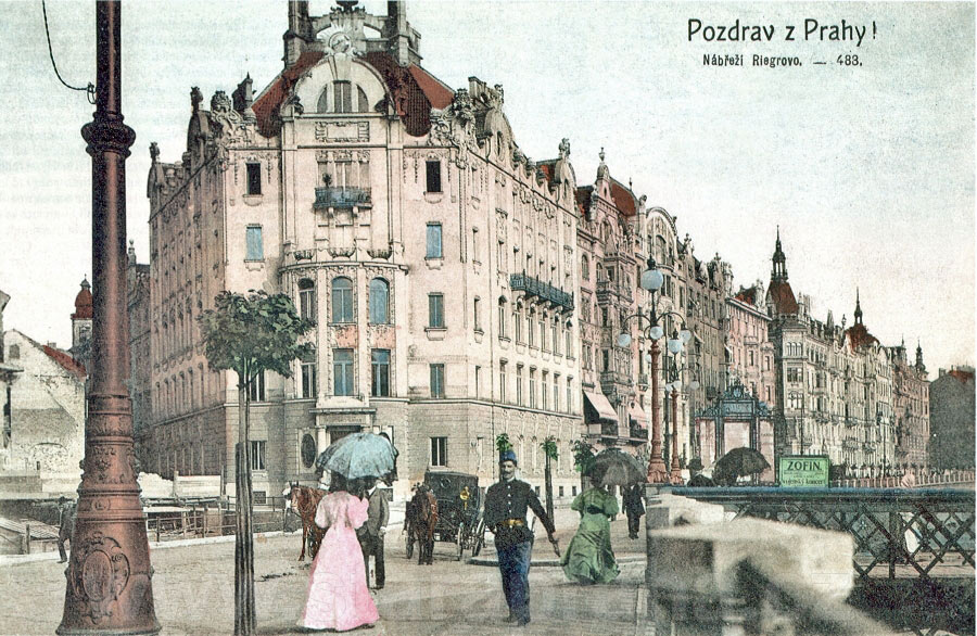
The newly completed street front of the Riegrovo Embankment with its eclectic and Art Nouveau buildings, viewed from the footbridge leading to Žofín towards Myslíkova Street. Within the relatively short time of ten years an embankment quarter which offended the eye, covered with old buildings within a complex of crooked streets, managed to be converted into a well-arranged urban complex, linking the already completed embankment units from the National Theatre and from the Palacký Bridge. The embankment became a source of pride for Prague in the period, and shortly afterwards a favourite promenade. On the left, at the corner of Na Struze Street, you can see the demolition site of No. 227, which shall soon see a new building bearing a Gothicised facade by G. Papež. The new Art Nouveau building on the opposite corner - The First Bohemian Ensuring Bank - designed by J. Stibral and with sculptural work by L. Šaloun, new No. 224, constitutes a monumental architectural entrance to the embankment from this side. PHOTOTYPE. AROUND 1906 |
top of the page history Podskalí postcards Podskalí |
